The Faculty of Geography at Universitas Gadjah Mada (UGM) is organizing a Summer Course on Ecosystem-based Disaster Risk Reduction and Climate Change Adaptation (Eco-DRR & CCA) from August 21st to 26th, 2023. The course will be conducted in a hybrid format at the Faculty of Geography. The Summer Course Eco-DRR & CCA Opening Ceremony was held, attended by 23 participants and 10 resource persons from 5 countries. The opening remarks were delivered by the Program Coordinator, Dr. Dyah Rahmawati Hizbaron, M.T., M.Sc, The Vice Dean for Research, Cooperation and Alumni, Faculty of Geography, UGM followed by comments from representatives of the Southeast Asian Regional Center for Graduate Study and Research in Agriculture (SEARCA) Office.
Uncategorized
Monday, 30th July 2018
1. Junun Sartohadi – Ecosystem Based DRR through geo-pedological approach at the volcanic transitional landscapes
2. Sunil Kumar De – Disaster risk Management in the Tropics: Geomorphological Perspective
Wednesday, 1st August 2018
1. Tsung-Yi Lin – Shoreline Changes and the Consequences of Climate Change
Thursday, 2nd August 2018
1. Estuning Tyas Wulan Mei – Crisis Management during Volcanic Eruption
Friday. 3rd August 2018
1. Zulfa Hanan Ash’aari – Better Air Quality In Asia: Regional Action, Global Impact
2. Decibel V. Faustino-Eslava – Geohazards, tropical cyclones and disaster risk management in the Philippines: Adaptation in a changing climate regime
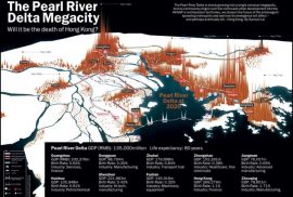
Dr. Dyah R. Hizbaron, focused on Vulnerability Analysis. This was primarily done by using the example of urbanization, and even more so by using the case of the Guandong Delta in China. However, the lecture began by listing different elements of risk, hence having the potential of being vulnerable, including structures, economy, natural resources and society. Dr. Dyah R. Hizbaron here in particular points out the difference between physical hazard, used in geography and with quantitative approaches, and social hazard, as used in social sciences and is approached through qualitative method. Significant to mention are three basic terms when thinking about vulnerability which are vulnerability, meaning the possibility to escape a stressful situation, capacity, the capability to escape a stressful situation either through coping, adaptation or resilience, and hazard, meaning an event creating shock or stress. Furthermore, it is explained that the probability of losses must be added in order to measure risk, i.e. how much is affected. This is than added to the elements of hazard and vulnerability, ultimately leading to number which describes a risk. The conceptual framework is than utilized by using the case example of the Guandong Delta which reveals an increased risk accordingly to an increased urbanization. It is also pointed out that this could be the case for several locations on Java as well.
Dr. Junun Sartohadi presented an example of Eco-DRR in practice with a focus on ecosystem resilience for natural hazard mitigation. In particular, he focussed on the spatial rearrangement of local trees and crops to optimise the ecosystem’s benefits to the local communities. He took the example of an erosion-landslide- drought prone area, the Bompon Sub-watershed in the Magelang District, Central Java. The main objective was to formulate an effective conservation strategy, based on soil-water conservation techniques which are able to mitigate the risk to natural hazards. Most importantly, the proposed system had to be accepted by the community and was meant to improve land cultivation and productivity, consequently generating an economic income. Given the sensitivity and average thickness of the layers of the soil in that area as well as the absence of effective trees rooting systems that would prevent the soil from sliding, the purpose was to determine which crops/trees are providing either daily, seasonal or annual income – the dominant crops/trees. Overall, the land management of the Bompon Sub- watershed was improved through the cultivation of permanent trees and light weight crops, such as coffee, rambutan, durian, etc. The spatial rearrangement was described as a win-win solution enhancing economic productivity while causing minimal land disturbance.
Geomorphology studies why landscapes look the way they do, their forming history and dynamics as well as try to predict future changes, with focus on what happens on the surface and above it. In order to understand the concept of disaster, we should understand some of frequently basic terms such as hazard, exposure, vulnerability, capacity, risk and disaster and how its definition might change according to the context it happen in, as different countries look at hazards and calamities differently. Hazard is defined as a dangerous phenomenon, substance, human activity or condition that may cause loss of life, injury or other health impacts, property damage, loss of livelihood & services, social & economic disruption or environmental damage. Hazard is a potentially damaging phenomenon that could be caused by natural or human-induced. Some of the examples of hazard are typhoon, extreme rains, earthquake, tsunami, severe flooding, rain-caused landslide, and rough seas. Exposure is the degree to which the elements at risk are likely to experience hazard events of different magnitude. Vulnerability is the characteristics of a community, system or asset that make it susceptible to the damaging effects of a hazard. This may arise from various physical, social, economic & environmental factors. Vulnerability comprises of three components such as: (1) social integration; (2) physical vulnerability; (3) psychological. Capacity is the combination of all strengths and resources available within the community, society or organization that can reduce the level of risk or effects of a disaster. Risk is the combination of probability of an event to happen and its negative consequences, while disaster is a natural or man-made hazard resulting in an event of substantial extent causing significant physical damage or destruction, loss of life, or drastic change to the environment.


